MoCoClosures Winter Forecast 2024-25
Written by our Forecaster DarkSharkWX (@shark_wx on X, formerly Twitter)
Winter is coming! With it comes the uncertainty of snow days, icy commutes, and stormy weekends. At MoCoClosures, we’ve spent weeks analyzing historical data, long-range models, and regional patterns to bring you the most reliable and detailed winter forecast for the 2024-25 season.
In this comprehensive forecast, we’ll explore projected snowfall totals, peak storm periods, and the overall chances of winter weather disrupting daily life across Montgomery County and the broader DMV region. Whether you’re a student hoping for snow days or a commuter preparing for icy roads, this outlook will help you plan for what’s ahead.
Disclaimer: Long-range winter forecasts are extremely challenging due to the unpredictability of atmospheric patterns and many things that could go slightly different within those three months. While we strive for accuracy, shifts in conditions will lead to unexpected outcomes. Use this outlook as a guide, but stay tuned for updates throughout the season as we refine our predictions.
THIS IS A LOW CONFIDENCE FORECAST. We will be issuing updated forecasts as conditions develop later in the season.
Current Conditions:
East-Based La Niña/Cold Neutral (Somewhat Favorable for Snowfall/Winter Events)
Strong -PDO( Very Unfavorable)
+QBO(/Solar Max (Unfavorable/Favorable aspects balance each other out)
Tropical Western Pacific Warm Pool, Warm Indian Ocean (Favorable)
Warm Atlantic (Can be favorable/unfavorable depending on cold air available at the time)
Snowfall:
I predict slightly below normal to normal snowfall, and the highest snowfall total in 6 years - since 2018-19, including 2021-22 and last year. The last nine years have been the worst period of snowfall in the history of the mid-Atlantic, with almost every winter being warm and below normal. We’ve also had three winters under 10” of snowfall since 2016. We could see more snow if the tropical Western Pacific (WPAC) warm pool expands further east faster, the La niña fails to develop even more, and we continue seeing the warm pool off of Japan cool (making the Pacific Decadal Oscillation [PDO] rise and be less hostile).
In Montgomery County:
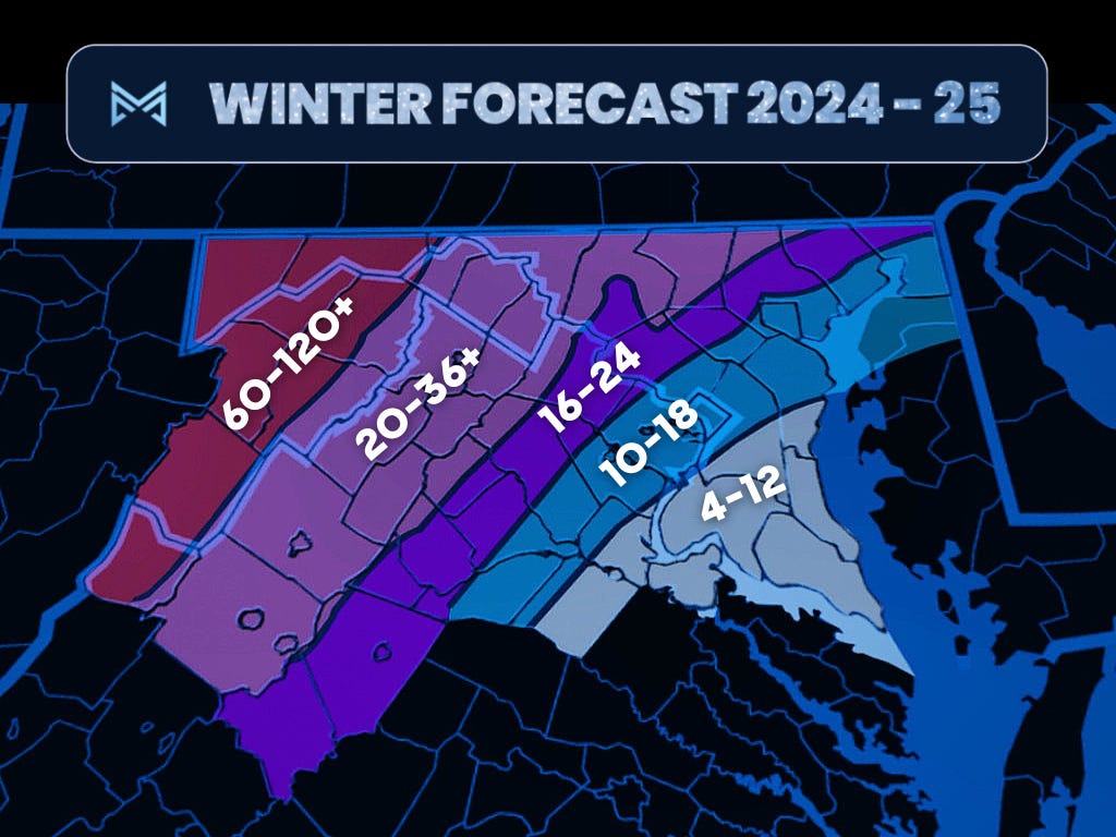
12-18” for southern MoCo, 16-24 for central-northern MoCo, 20-28” for Damascus and northeastward.
Region-wide:
10-18” I95, 4-12” SE of 95, 16-24” NW of I-95, 20-36”+ for west of Route 50 and North of Interstate 70 (well NW of I-95), and 60-120”+ for the mountains.
Temperatures:
+2-4F for Dec, below normal snowfall
-2 to +1F for Jan, normal to slightly above normal snowfall
0 to +3F for Feb, slightly below normal - normal snowfall
For ease of understanding, here are a few of the acronyms I repeat throughout the forecast.
PNA - Pacific North American (positive phase is good)
MJO - Madden Juilian Oscillation (phases 7/8/1 are good)
EPO - East Pacific Oscillation (negative phase is good)
WPO - West Pacific Oscillation (negative phase is good)
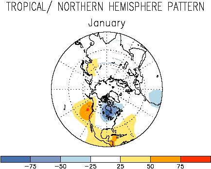
TNH - Tropical North Hemisphere (positive phase is good)
AO - Arctic Oscillation (negative phase is good)
NAO - North Atlantic Oscillation (negative phase is good)
I predict December to be relatively mild overall, with an unfavorable -PNA pattern. However, we overturn the pattern as the MJO makes it into more favorable phases starting in late December and lasting throughout most of January.
January is likely to be the coldest month of this year, with a dominant +TNH pattern and plenty of cold air available. We can also get a favorable Pacific pattern, with +PNA centering the cold on the eastern US, suppressing the southeast ridge, and giving us a favorable storm track, in addition to the -EPO/-WPO bringing cold down into the Continental United States (CONUS). This is our best chance to see a significant snowstorm, and I do think we see at least one-two warning level events this year.
February is likely a mix between -PNA and +TNH patterns, and this is the month we will see the most wild swings in. I could see a war between the coupling of the +TNH to the stratosphere (which would support and reinforce said pattern) and the climatological eastward expansion of the warm pool in the tropical western Pacific (favorable for a +TNH/-EPO pattern) competing with unfavorable subseasonal forcing (MJO going back into warmer phases) and shorter wavelengths (supports a more -PNA pattern).
Although I’m favoring a warmer month, this could be the coldest month of this winter if the +TNH wins, since the +TNH can couple more with the stratospheric polar vortex as winter progresses (if it does couple). Some of the coldest Feb niñas are +TNH niñas - although usually, February is a very mild torch for the eastern US in a canonical niña. That is why I gave more room for margin for this month.
Although I don’t expect a major storm, I could see the possibility of a widespread 6-10” storm this year for the I-95 corridor if we can time a wave properly with +PNA/-EPO/+TNH in place. Either way, I think we see some moderate-significant events this year (3-6/4-8” events), as well as a lot of overrunning/CAD events - which are snow -> mix -> rain or rain -> snow, especially in February, and maybe mid-late December. I expect quite a bit of wintry mix events, including one where we barely get any snow, and it's mostly ice. February is a wildcard and could go either way and will have a lot of wild temperature/weather swings due to the competing forces. I think there will also be one big arctic outbreak for the central-eastern US this winter.
This winter, at the very least, will be quite active to track, more so than in recent years, due to the competing forces. The overall pattern mimics a mix of 2013-14(very extreme and snowy +TNH winter), 2021-22, 1988-89, 1983-84, and 2020-21. I expect a healthy +AO/+NAO, but even if we do see -NAO, it will be east-based, which won’t add much to the pattern.
Example of a +TNH pattern - I expect January to look something similar to this.
POSSIBLE SCHOOL IMPACTS
I think as for school closures, we see at least 2-4 closures this year, with potential for more, with a high likelihood delays due to Wintry mixes. There is a decent likelihood of having more impacts than last year (for MCPS, it was 3 snow days & 2 delays), but it depends on the timing of storms/how many ice events we can get, and various weather factors, which I elaborate on next.
IN-DEPTH REASONING:
When I forecast winter, I look at 3 main things: the tropical Pacific(ENSO/MJO), the North Pacific(PDO/GoA/Western NA), and QBO/solar.
We still currently have a strong -PDO, driven by the anomalously warm pool right off Japan, but we have seen significant cooling in that region these past two weeks. Nonetheless, the PDO will stay negative throughout the entire season and will remain quite healthy. It’s not the most classic-looking -PDO, with the tropics not cooperating, but nonetheless, it will be important. -PDO is not good for our region as it supports an Aleutian ridge and western trough(-PNA), which helps pump that southeast ridge, giving our region mild and dry conditions. We saw a very persistent pattern like this in 2022-23, and none of the region got over an inch of snow that winter. This is very unfavorable.
We are in an east-based La Niña right now - cold anomalies in the equatorial pacific, but they are centered well east of the international dateline, with tropical western pacific warmth between 120E–180W, with the bulk of it centered at 150-160E. What determines a central pacific and east-based niña is what happens in and around the international dateline. If we had a central pacific niña, not only would it be more developed and stronger, but the cold anomalies would extend well past the dateline. A central-pacific niña is bad because it would force convection (MJO) into warm phases, blocking it from reaching colder phases that would give us a more favorable pattern for snow and cold, therefore reenforcing the -PDO and the canonical niña pattern that the -PDO would support. Whereas, an EP niña would allow for a more poleward, favorable ridge position in the Pacific, going from an Aleutian ridge to a GOA ridge, and it would also allow us to make it into colder MJO phases, giving us more chances to receive snow. The last EP niña we had was 2021-22, which gave us our last semi-widespread 6-12” storm (Jan 3rd, 2022), and also had the coastal Mid-Atlantic/New England blizzard. The last CP niña we had was the infamous year of 2022-23, our least snowiest winter in history. We didn’t even break an inch that year because of the overwhelmingly strong unfavorable pattern; MJO was constantly stuck in unfavorable phases, and the Pacific was so horrible to the point where we were very warm and mild, with almost no chances of snow. So an EP niña, although not the most favorable ENSO(this would be a central-based El Nino), is somewhat favorable, especially for north and east of the mid-Atlantic.
The driver of our weather is Madden-Judden Oscillation (MJO), and this is essentially just convection in the tropical Pacific that moves eastward around the tropics and cycles every 30-60 days. It affects our patterns and therefore our weather downstream through mechanisms like the Pacific/Atlantic jet. MJO and its impacts are variable, and the “actual base state” through which these waves propagate is very complicated, but that’s all you need to know to understand the reasoning.
We currently have a westerly +QBO (westerly stratospheric winds above the equator) and a solar max (max sunspots of this solar cycle— the reason why we’ve had so many anomalous auroral events recently), which would support a strong polar vortex, which would prevent Atlantic/Arctic blocking, supporting +AO/+NAO. This is not good for us, as -NAO/-AO would bring colder conditions and help storms lock in the source of cold air.
The most significant thing to me is the very weak niña/cold neutral and the warm pool located at ~160E. This warm pool will not only support convection into the western pacific(cold/favorable MJO phases), but this supports more north pacific blocking and a +TNH pattern.
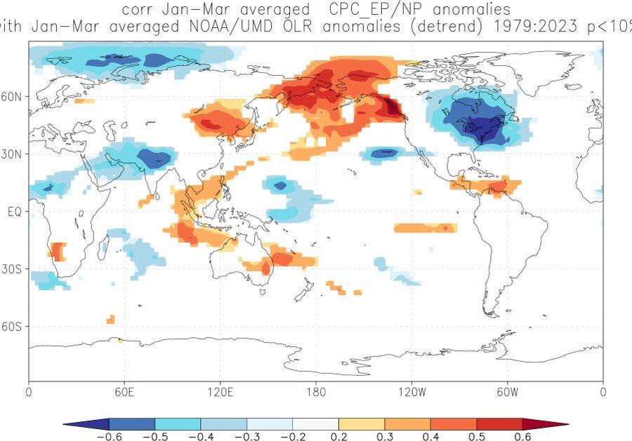
This is because increased convection near the surface leads to sinking air and ridging(blocking) over the higher latitudes of the NPAC, leading to -WPO/-EPO and providing more cold air into the CONUS. You can also see the +TNH here, with rising air and troughing (Hudson Bay “polar vortex” pattern over central and eastern Canada). This is associated with strong Arctic outbreaks over the CONUS, along with the aid of -EPO/-WPO funneling down cold air from the high latitudes. This is favorable for us as this is where we’d get our cold air from, and it also supports ample snow cover to our north, meaning that we will have a great cold air source that we will be able to tap into when MJO goes into favorable phases and we get a good Pacific pattern and shunt the southeast ridge away.
At ~160E you can see the clear warm pool, with the highest SSTs(not SSTAs) in the world centered at the equator at 160E.
We will likely see a hybrid between -PNA (Canonical niña) and +TNH pattern, but most likely leaning towards a +TNH pattern because of the eastern extent of this warm pool as well as the warm Indian Ocean. Warm IO adds more westerly momentum to the jet, which would make -PNA episodes slightly less frequent in comparison to a cooler IO. This is because of the additional latent heat release which would increase the meridional temperature gradient in the upper troposphere, which would accelerate the jet stream and push the exit region further out into the Pacific.
The -PDO being this strong means that when MJO is in unfavorable phases, warm periods will have a southeast ridge raging, but this also opens the door to gigantic temp/weather swings, especially in February. As winter goes on, the stratospheric polar vortex tends to strengthen, but this could also mean that the +TNH pattern would couple with the SPV, which would reinforce and support said pattern - which is why a lot of +TNH winters break the mold of a typical niña and have a colder jan-feb than December.
During +TNH winters, +NAO/+AO is prevalent because of a strong SPV - this means that a chance of us getting a widespread major storm is unlikely because you need -NAO to slow down the storm so that it can drop the level of snow accumulations it needs to be classified major.
Analogs Used(ending year listed, so 2014 is 2013-14, with weightage):
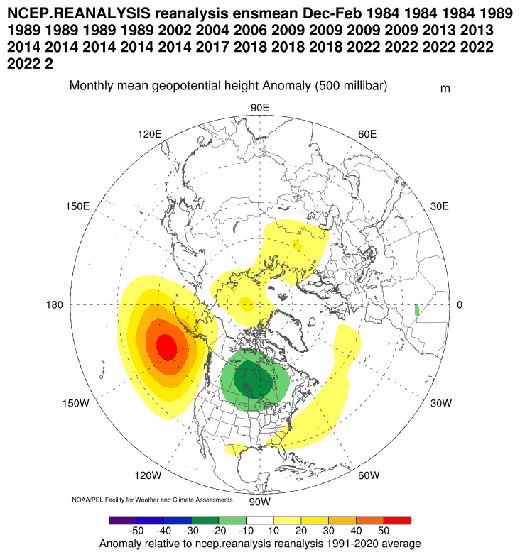
2013-2014(5x), 2021-2022(5x), 1988-1989(5x), 2008-2009(4x), 2017-2018(3x), 1983-1984(3x), 2012-2013(2x)
2001-2002, 2003-2004, 2005-2006, 2016-2017, 2022-2023 1984,1984,1984 1989,1989,1989,1989,1989 2002 2004 2006 2009,2009,2009,2009 2013,2013 2014,2014,2014,2014,2014 2017 2018,2018,2018 2022,2022,2022,2022,2022 2023
Dec-Jan-Feb Composite(+TNH/GOA Ridge):
These factors directly influenced this forecast.
East-Based La Niña/Cold Neutral (Somewhat Favorable for Snowfall/Winter Events)
Strong -PDO( Very Unfavorable)
+QBO(/Solar Max (Unfavorable/Favorable aspects balance each other out)
Tropical Western Pacific Warm Pool, Warm Indian Ocean (Favorable)
Warm Atlantic (Can be favorable/unfavorable depending on cold air available at the time)


